Rutas
Te dejamos todas las rutas que puedes realizar. Posibilidad de hacer las rutas con guía.
-
-
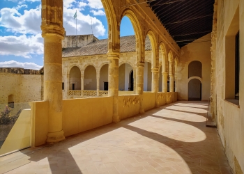
MONUMENTAL ROUTE OF BORNOS
Starting Point: Bornos.
Duration: 2 hours.
Difficulty: Easy.
ROUTE OF THE CROSS
Starting Point: Plaza de San Francisco.
Time: 1 to 2 hours.
Difficulty: Easy.
RUTE WAY OF THE DAM
Starting Point: La Islita.
Difficulty: Easy.
Time: 2 hours round trip.
Way of the mountains
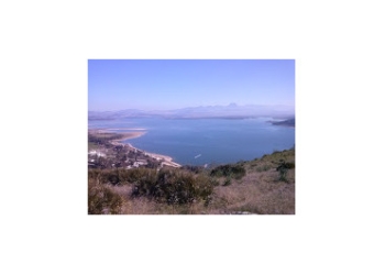
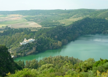
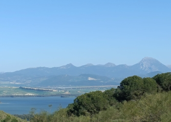
From the road located in the Sierra del Calvario to the “Tajo “(located at the edge of the Lake), lovers of natural medicine will find this tour especially interesting because of the great variety of wild plants of curative character that grows in this area of the Sierra de Bornos. In addition, you can enjoy particular fragances and a magnificent view of the Villa of Bornos, the Lake and the Sierra de San Cristóbal. From this place, you can admire the tonality of the sky and its variations depending on the day. There is a balcony at the entrance to the "Carretera Vieja" with a splendid landscape of Sierra de San Cristóbal.
Starting Point: Sierra del Calvario
Difficulty: Easy
Time: 1 to 2 hours
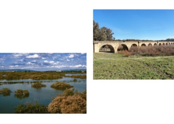
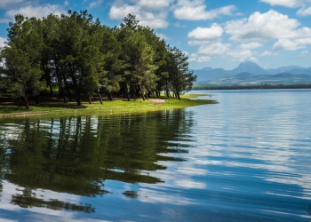
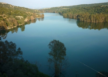
Section of the Greenway and Natural Park "Cola del Embalse de Bornos"
The Vía Verde(Greenway) was designed on the unfinished Jerez-Almargen railway line. This path is a section of the Greenway and pass througt Bornos and Coto de Bornos and invites you to make some beautiful photographs in the Bridge of the 21 Eyes. This path is very conducive to the practice of hiking and cycling. The Cortijo Las Pitas is halfway to this itinerary and from there you can see the protected fauna of the Natural Park "Cola del Embalse de Bornos". A total of 830 hectares of surface flanked by soft slopes with olive trees and an abundant vegetation.
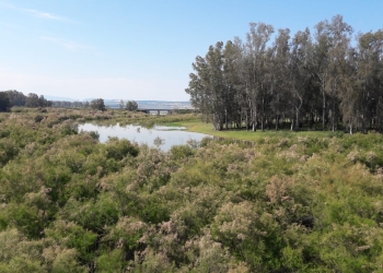
The space called "Cola del Embalse de Bornos" was declared, in a session held by the Plenum of the Andalusian Parliament, on 27 and 28 June 1989, Protected Natural Place of Andalusia. In it there is an area that is flooded when the level of the reservoirs increases. This area, covered by an abundant marsh vegetation, where an important and spectacular formation of taramar (Tamarix africana) is developed, constitutes an important nesting area for water birds.
From the zoological point of view we must point out that (Lutra lutra) lives in this area and has been recorded some interesting birds as the osprey (Pandion haliaetus). Important is the presence of a large colony of Ardea cinerea, imperial herons (Ardea purpurea), gazettes (Egretta garcetta), spulgabueyes (Bubulcus ibis) and martinetes (Nycticorax nycticorax).
Starting Point: the Vía Verde. Embarcadero
Difficulty: Easy
Approximate travel time: 4 hours round trip
-
Route der Baudenkmäler
In Bornos können Sie an einer Führung zu den wichtigsten Baudenkmälern teilnehmen. Sie beinhaltet das Castillo – Palacio de los Ribera mit seinem Renaissancegarten, die Iglesia de Santo Domingo de Guzmán und das Convento del Corpus Christi. Auf dieser Route wird das reiche kunsthistorische Kulturerbe dieser Ortschaft hervorgehoben, das aufgrund seiner Ansammlung von Monumenten das zweitwichtigste in der ganzen Sierra de Cádiz darstellt und Bornos als Wiege der Renaissance Niederandalusiens auszeichnet.
Ausgangspunkt: Bornos
Dauer: 1 bis 2 Stunden
Schwierigkeitsgrad: einfach
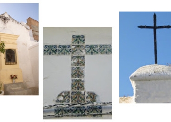
Route des Kreuzwegs
Diese Strecke lädt dazu ein, dem alten Verlauf des Kreuzwegs vom Convento de San Bernardino bis zum Kalvarienberg zu folgen. Dieser Weg vereint sich mit dem ersten Kreuzweg Spaniens, der vom Convento de Santa María del Rosario in Bornos bis zum Cruz Esperilla eingerichtet wurde. Ausgangspunkt ist das Touristikinformationsbüro, obwohl die eigentliche Strecke am Plaza San Francisco beginnt und bei der Ermita del Calvario endet.
Ausgangspunkt: Bornos
Dauer: 1 bis 2 Stunden
Schwierigkeitsgrad: einfach
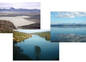
Staudammweg
Vom Inselchen aus (Steinhügel am Bootssteg, der bei ausreichend hohem Wasserstand des Stausees wie eine Insel vom Wasser des Flusses Guadalete umspült wird) kann man bis zum Staudamm von Bornos eine wunderschöne Naturlandschaft genießen. Dieser Weg könnte auch gut „Weg des Taleinschnitts“ oder „Weg der Enge“ genannt werden, denn er führt an dem am tiefsten gelegenen Teil des heute vom See bedeckten Tales entlang. Durch diesen Taleinschnitt floss der Guadalete dahin, und durch ihn führte auch im 18. Jh. der Weg nach Bornos. Am Ende des vergangenen Jahrhunderts plante man eine Bahnlinie, die in Jerez de la Frontera beginnend durch die Berge bis nach Almargen reichen sollte. Ein großer Teil der Strecke einschließlich Bornos wurde zwar ausgebaut, jedoch aufgrund eines zu geringen Budgets nur bis Arcos de la Frontera fertiggestellt. Trotzdem ist bis heute dieser Weg, der sich durch die Berge zog, zwischen Arcos und Bornos erhalten geblieben. Entlang des Abschnitts vom Staudamm bis zum Inselchen passiert man Tunnels und felsige Hohlwege von wildromantischer Schönheit. Zeit: ca. 1 Stunde, einfache Strecke.
Ausgangspunkt: Inselchen
Zeit: 1 Stunde (einfache Strecke)
Schwierigkeitsgrad: einfach
Weg durch die Sierra
Die alte Nationalstraße in der Sierra del Calvario ist der Ausgangspunkt dieses Weges, der bis zur Felswand am Ufer des Stausees führt. Liebhaber der Naturmedizin werden diese Strecke wegen der großen Vielfalt an wild wachsenden Heilpflanzen, die hier in der Sierra de Bornos heimisch sind, besonders interessant finden. Sie können sich sowohl an den speziellen Aromen als auch an der fantastische Aussicht über Bornos und den Stausee bis zur Sierra de San Cristóbal im Hintergrund erfreuen. Da der Himmel je nach Tageszeit in immer neuen Farbvariationen erstrahlt, lohnt es sich, diese Enklave wiederholt zu besuchen. Am Anfang der als „Carretera Vieja“ bekannten Straße wurde ein Aussichtspunkt eingerichtet. Von hier aus können Sie besonders gut die Sicht auf die prächtige Sierra de San Cristóbal genießen.
Ausgangspunkt: Sierra de Calvario
Zeit:1 Stunde (einfache Strecke)
Schwierigkeitsgrad: einfach
Streckenabschnitt "Via Verde"
Eine Vía Verde ist eine ungenutzte Bahntrasse, die im Rahmen des Vías Verdes-Programmes in Reiserouten für Radfahrer und Wanderer umgewandelt wurde. Auf der nie fertiggestellten Trasse Jerez-Almargen wurde in rein ländlicher Umgebung eine Vía Verde eingerichtet. Der hier beschriebene Abschnitt folgt einer grünen Schneise, beginnend vom Bootssteg Bornos bis zum Ortsteil Coto de Bornos und ist für Wander- und Radtouren besonders geeignet. Auf dieser Etappe befindet sich ein interessantes fotografisches Objekt: die Puente de 21 Ojos (Brücke der 21 Augen). Südlich von Coto de Bornos führt ein Abstecher zum Cortijo Las Pitas. Von dort kann man die geschützte Fauna der Naturlandschaft „Cola del Embalse de Bornos“ beobachten. Flankiert von sanften Hängen mit Olivenbäumen, wilden Pistazien und Tamarisken, die sich mit einer üppigen Sumpfvegetation vereinen, bildet die Fläche von 630 Hektar ein wichtiges Brutgebiet für Wasservögel: Nachtreiher, Kuhreiher, Seidenreiher, Taucher, Wildenten, Kormorane, Flamingos. Auch Nutrias und Aale bereichern die Vielfalt.
Ausgangspunkt: Bootssteg Bornos
Entfernung: ca. 8,5 km
Zeit: gut 2 Std. (einfache Strecke)
Cañada (Viehtriebweg) de Morón bis Carissa Aurelia (Ausgrabungsstätte)
Kurz bevor man Bornos aus Richtung Arcos de la Frontera kommend (A-389) erblickt, erreicht man einen Abzweig. Von hier aus folgt man der Cañada de Morón bis zu den Ruinen der Ausgrabungsstätte Carissa Aurelia. Von der Sierra de Bornos aus, wo der Schafstreibeweg beginnt, können Sie erneut atemberaubende Aussichten genießen. Der lange noch verbleibende Weg überquert Bergrücken und führt an mehreren Gehöften vorbei, immer parallel zum Gipfel des San Cristóbal. Von den Ruinen aus können Sie den Rückweg über eine Landstraße wählen. Da es sich um eine etwas längere Marschroute handelt, sollten sie für diese Strecke gut in Form sein.
Ausgangspunkt: Bornos – Arcos de la Frontera
Zeit: 6 Stunden
Schwierigkeitsgrad: einfach
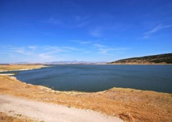
RUTA CIRCULAR HASTA LA PRESA
TRAMO DE LA EXTENSA VEGA DE BORNOS
Sendero circular comienza en la zona de El Embarcadero y discurre paralelo a las orillas del embalse de Bornos por la variada vega de Bornos ,completado con un ramal que toma un tramo de la llamada Vía Verde y culmina en en el Embarcadero de nuevo.
Longitud: 3 kms. Ideal para hacer en familia, a pie o en bicicleta. Desnivel y dificultad bajos.
RUTA TRAMO DE LA VÍA VERDE
Punto de Partida: Embarcadero de Bornos.
Tiempo: 4 horas ida y vuelta (17km).
Dificultad: Fácil.
RUTA DEL VIACRUCIS FRANCISCANO
Punto de Partida: Plaza de San Francisco.
Tiempo: 1 a 2 horas.
Dificultad: Fácil.
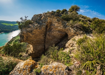
SENDERO SL- 438:SOBRE LA SIERRA
Descubre una de las panorámicas más espectaculares de la comarca a través de este sendero que recorre el cordal de la sierra situada al noroeste del casco urbano
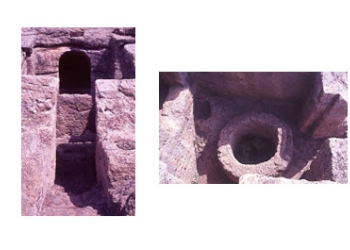
RUTA DE LAS FORTIFICACIONES
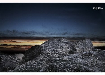
Durante la Guerra de la Independencia se fortificó Bornos y tuviéron lugar aqui dos importantes batallas. Restos de aquellos fuertes son el Pozo de los Moros y el Pozo de los Cristianos.
Llamanos e infórmate sobre la visita guiada.
CAÑADA DE MORÓN HASTA CARISSA AURELIA
Punto de Partida: Bornos - Arcos de la Frontera.
Tiempo: 6 horas.
Dificultad: Fácil.
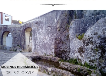
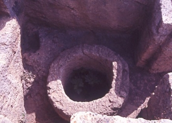
RUTA DE LOS ANTIGUOS MOLINOS DE AGUA